-
Wayfinding signs are about to go mainstream + Video

The Knight Foundation has announced it will fund a large-scale expansion of Matt Tomasulo’s "WalkRaleigh" project.

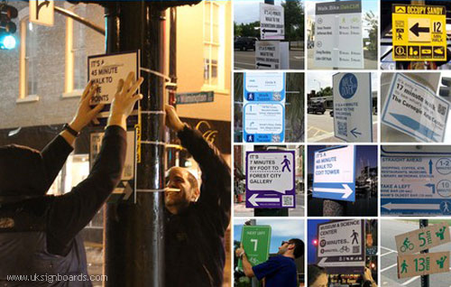
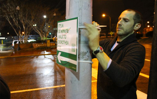
It started as a technically illegal exercise in improving how people experience the streets of Raleigh, North Carolina. Just some simple signs, lashed to light poles, at a few of the city’s key intersections, letting residents and visitors know what attractions and amenities could be found within walking distance and how many minutes it would take to reach them on foot. “Guerrilla wayfinding” is what people called it.
The signs, the brainchild of then-graduate student Matt Tomasulo, were meant to help people think differently about distances in the city, and to encourage them to get out of their cars and explore the place under their own power.
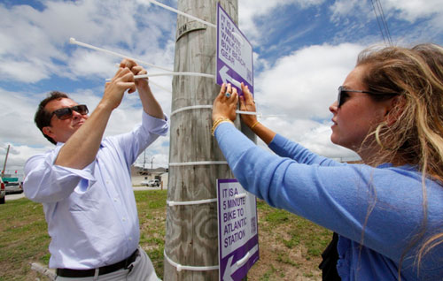
When it debuted, the project drew international notice and received lots of favorable press coverage, including here on CityLab. It also got the attention of Raleigh’s city government, which eventually took the signs down for violating local ordinances. But the city’s planning director was a fan of the concept behind Tomasulo’s action, and soon they reached a compromise. The signs went back up, with the blessing of the city, as a pilot education project.
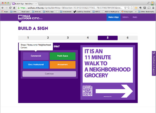
Tomasulo then launched a Kickstarter campaign to create a website, Walk [Your City], that would allow activists around the country to design their own low-cost wayfinding signs, complete with QR codes that users can scan for detailed directions. Since its inception two years ago, more than 100 communities have ordered signs through the site—places like Mount Hope, West Virginia, a town of 1,500 that created 70 guideposts for tourists who would be coming to town for a big summer event.
In communities such as Mount Hope, it’s not just newcomers who benefit, though. The signs, with their clean graphics and large lettering, direct residents to spots such as an elementary school or local ballfields, letting them know that these places really aren’t very far away—and sending the signal that they can be reached without a motor vehicle.
“We have talked and talked and talked about creating a healthier community,” says Michael Martin, a Mount Hope native and the town’s current mayor, in a video about the project. “A healthier community because we get out and walk… because we exercise. We haven’t done a whole lot about that up until now, but I think this will allow us to do a little more. I had to take a new look and a fresh look at my own community. And it was pretty interesting for me to do.”
Tomasulo’s intent from the beginning was to foster this kind of re-envisioning of a community’s geography, and to give local residents the power to create change quickly, easily, and cheaply. As Walk [Your City] has evolved, though, he realized that both the software and the engagement process needed to be developed and strengthened.
This week, thanks to a $182,000 grant from the Knight Foundation, Walk [Your City] announced it is launching pilot projects in Lexington, Kentucky, and San Jose, California, designed to bring its methodology to the next level.
“So many communities are interested in Walk [Your City] campaigns as an immediate solution to their bike/ped needs,” writes Tomasulo in an email. “But we’ve realized through our work the last 1.5 years that so much is missing to complete that process. We have learned a tremendous amount, and it is our goal to transfer that knowledge (in addition to what we learn in Lexington and San Jose) into tools that help communities plan for people more quickly, easily, and in less expensive ways.”
Working with government and community partners, Walk [Your City] will be conducting “wayfinding campaigns” in Lexington and San Jose designed to educate and engage citizens about how to plan for more walkable communities. The final goal, says Tomasulo, is to release a “truly DIY walkability toolkit” by the end of 2015, one that will allow communities to integrate wayfinding campaigns into the traditional planning process.
“We will be significantly investing in software, evolving from a product to a true platform that will incorporate what we’ve learned from visioning and planning pedestrian campaigns,” writes Tomasulo. “We will be able to better understand what types of engagement are possible: both through participatory planning processes while developing a campaign, as well as how residents can interact with the campaigns post-installation.”
Walk [Your City] has clearly moved past the “guerrilla” stage at this point. But that doesn’t detract from its usefulness in so many U.S. communities—where the idea that you can walk instead of drive to your destination remains a radical one.
$this->BBvideo_pass(‘$8’, ‘$4’, ‘$7’)
For more information:
https://walkyourcity.org/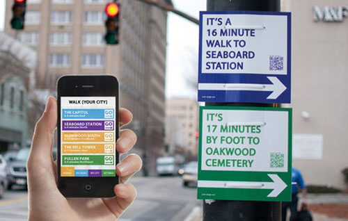
.

Log in to reply.